A pressing need to transport freight and people led to the building of Centre County’s only canal by the Bald Eagle and Spring Creek Navigation Company.
In 1825, the state of New York opened its iconic Erie Canal, connecting Buffalo with Albany and via the Hudson River, with New York City. The canal was wildly successful and sparked “canal fever” in surrounding states.
Early Pennsylvania canal projects were small and privately financed, but they did not address the need for an east-west connection across the state. In 1826, the state began the Pennsylvania Canal – a combination of rail and canal, including the Allegheny Portage Railroad and the Philadelphia and Columbia Railroad – to link Philadelphia and Pittsburgh. Soon, the system expanded across the commonwealth, and along the West Branch of the Susquehanna River to Lock Haven.
Bellefonte’s leaders, however, still pressed for a connection to Pennsylvania’s network of commerce. Central Pennsylvania, with its dense forests, poor roads, and many mountains, posed difficulties for moving goods by wagon and flatboat. The nascent railroad technology was not yet perfected, and canals were thought to be the best solution to the problem.
A large portion of the company’s initial capital came from Philadelphia investors, including sugar refiner Charles I. Lex and R & J Philips’s merchant house. Unlike most canals in the state, the BE&SC was privately funded, but the Commonwealth guaranteed 5 percent interest on $200,000 of its stock, which made it an attractive and secure investment.
In 1834, a number of Centre County’s wealthy families helped create the Bald Eagle and Spring Creek Navigation Company. Among its first managers were Judge Thomas Burnside; Roland Curtin, owner of Eagle Ironworks; and ironmaster James Irvin, who later donated land to help establish the Farmers’ High School of Pennsylvania that would become Penn State.
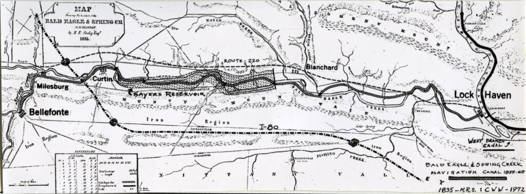
In 1835, Burnside hired canal engineer Matthew Stealey to design and lay out the course of the canal. From a basin near the corner of Lamb and Water streets in Bellefonte, the Navigation paralleled Spring Creek to Milesburg, followed Bald Eagle Creek through Curtin, and passed near Howard to Mill Hall.
The route’s last four miles from Mill Hall to Lock Haven were by way of the state-constructed Bald Eagle Side Cut Canal, which, in turn, connected to the West Branch Division of the Pennsylvania Canal that ran along the West Branch of the Susquehanna River to Northumberland.
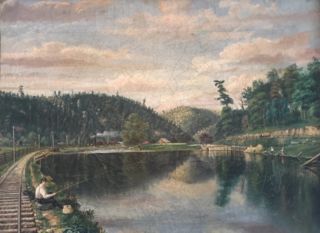
The canal was 25 miles long, 20 miles of which were hand-dug with pick and shovel, and the remaining 5 miles were “slackwater,” that is, navigating in the creek where the water depth was raised by nearby dams. Total lockage – the sum total of lift in all locks of a canal – was 183 feet, requiring 22 lift locks and six guard locks. (Guard locks protect the canal from damage from high water; they also function to supply sections of the canal with water when required.)
Five new dams were constructed on Spring Creek and five mill dams were heightened and repaired. The estimated cost in 1835 was $275,000, but actual costs kept rising as prices for labor and materials increased. By 1838, the total cost had increased to $318,000, and it took 10 more years of intermittent construction for completion. There were no aqueducts on the Navigation or the Side Cut; crossings of the Bald Eagle were taken care of by dams and towpath bridges.
The prism – the shape of the canal as seen in cross section – of the BE&SC was slightly smaller than the state-owned canals: 36 x 4 x 20 feet versus 40 x 4 x 28. But it was the standard depth of four feet that was important because boats on the narrower Bald Eagle could pass at the frequent slackwater dams. Because of the abundance of the Bald Eagle’s watershed, the dimensions of the canal’s locks could afford to be the same as those of the state canals: 90 feet long by 17 feet wide, thus ensuring the Navigation could accommodate full-size standard Pennsylvania Canal boats.
Starting in 1835, the canal was built in fits and starts. It was divided into two sections: the Lower Division (12 ½ miles) extended from what is now Howard to Mill Hall and the Upper Division (12 ½ miles), from Howard to Bellefonte. In spring 1837 the first few miles of the BE&SC below Beech Creek were opened.
By August 1837, the Marsh Creek and Howard dams has been completed. On November 7, water was let in from the Howard Dam, which allowed the entire Lower Division to be opened on March 28, 1838. Water was let in from Bullit Run on October 6, 1838, and from Dowdy’s Hole, just below Eagle Furnace at Curtin, on November 1, 1838, making a total distance of 18.75 miles.
A number of factors delayed the completion of the Upper Division, including the Panic of 1837 and the resulting poor economic conditions of the country. The canal finally reached Milesburg on September 3, 1847, and the head of navigation at Lamb Street in Bellefonte on September 1, 1848.
Records show the canal enjoyed a thriving business at reasonable rates. In addition to transporting pig iron, bituminous coal, and limestone, it served as an outbound conduit for local agriculture traffic. In return, all matter of items were shipped from points east. Passengers also traveled on the canal.
However, unlike some larger canals, it did not feature passenger packets. The limited number of passengers may have been due to the relatively short run of the canal, as well as the long travel times a round trip between Bellefonte and Philadelphia could take ten weeks or more.
A major hiccup occurred in 1857 when the Pennsylvania Main Line canal was sold to the Pennsylvania Railroad. This proved to be a foreshadowing event for the BE&SC. Ironically, the canal helped in its own demise.
The railroad came to Bellefonte in the fall of 1859 when the Bellefonte and Snow Shoe Railroad opened for service over its entire distance of 25 miles and initially shipped coal from Snow Shoe to the “port” of Milesburg and its connection to the canal. The irony comes from the fact that the railroad’s very first locomotive arrived in Bellefonte, in pieces, via canal boats in May 1859.
The long-held dream of railroad developers to run a line down the Bald Eagle Valley between Tyrone and Lock Haven was now at hand. After false starts due to inadequate local investment, the Pennsylvania Railroad took financial control of the enterprise and opened a railroad running the entire length of the valley in 1865.
The nail in the coffin for the canal came in the form of spring storms in 1865, which caused massive damage to the entire system. Canal banks, locks, and dams were destroyed or damaged to the point where it was not deemed economical to repair them, especially in light of railroad competition. The Lower Division continued to operate for a few more years as far as the mouth of Beech Creek, where it served a large sawmill.
David Hilton Brown
Sources:
Brennan, Janet. “Centre County Canal,” Town & Gown, July 1979.
Brown, David Hilton. “Bald Eagle and Spring Creek Navigation,” Canal Currents, Issue 199, Spring 2022.
Coleman, Ernest H. “Bald Eagle and Spring Creek Navigation,” Canal Currents, Issue 19, Winter 1972.
First Published: February 25, 2023
Last Modified: November 20, 2023